White Iron Chain Of Lakes Association
Canada’s Science Activities in the Watershed
By Kelli Saunders
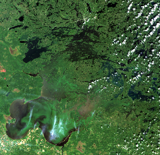
A few weeks ago, I outlined the work that Minnesota is doing to understand water quality on Lake of the Woods through its Total Maximum Daily Load study. Over the next few weeks, I will highlight the work on the other side of the border being done by Environment and Climate Change Canada (ECCC). For the past 3.5 years, ECCC has been conducting integrated research and monitoring to get a handle on water quality conditions and algal blooms. This has included projects such as the development of satellite tools to identify and monitor blooms; research into the status, trends and drivers of algae blooms; measuring nutrient inputs from shoreline developments; developing a model to help determine the effectiveness of nutrient reduction strategies on the water quality in Lake of the Woods; and, predicting the lake's response to climate change. They have been collaborating with other agencies who are also doing research in this basin. Today, I’ll focus on the satellite remote sensing project, with input from ECCC’s lead scientist for this project, Dr. Caren Binding.
 Remote sensing allows scientists to capture frequent snapshots of algal bloom conditions across Lake of the Woods in near-real-time (within a few hours of the satellite passing over), providing observations not possible using ground-based sampling alone. It provides the ability to see day to day variability of algal blooms on the lake, between-year changes in the size of blooms and timing of bloom severity and an understanding of the processes that drive blooms. How does this relate to what’s actually happening in the water, you ask? When present in sufficient quantities, phytoplankton (microscopic plant-like organisms including cyanobacteria) can cause dramatic changes in water color and form visible scums at the water’s surface that are detectable from space using camera-like optical sensors on-board the satellites. What is happening on the water can be interpreted in the satellite images over a large geographic area.
Algal bloom maps for Lake of the Woods are being produced daily during the open water season and are compiled into annual bloom reports that document the seasonal progression of the blooms. ECCC has developed a suite of bloom indices (extent, intensity, duration and severity) so that they can compare conditions over time.
At their peak, blooms have covered an area of 3000km2 (nearly 80% of the lake) and lasted up to 140 days. To date, 2019 has seen the lowest severity bloom on Lake of the Woods over the last two decades, but additional monitoring this fall will determine if that will still be the case. Satellite-derived bloom indices show significant seasonal and between-year variability in response to weather conditions but suggest a trend of decreasing bloom severity in recent years.
ECCC is developing a web mapping tool that the public will be able to use in the future to see bloom development online in near-real-time, access bloom reports, and historical data to track changes in bloom conditions.
Tune in next week for more on ECCC’s work in the watershed!
This series is provided as part of the International Watershed Coordination Program of the Lake of the Woods Water Sustainability Foundation www.lowwsf.com
When you subscribe to the blog, we will send you an e-mail when there are new updates on the site so you wouldn't miss them.