
White Iron Chain Of Lakes Association

News & Updates Blog
Nov
05

Give to the Max Day

Give to the Max Day returns on Thursday, November 14, 2019!

GiveMN launched in 2009 as a collaborative venture led by Minnesota Community Foundation and many other organizations committed to helping make our state a better place.

 WICOLA is a registered participant for GiveMN (Give to the Max Day – Nov 14).

Please consider making a donation by either;

  1. Going to the Give to the Max home page, Click on “Donate Now”, Type “WICOLA” in the Search Box, Click on the “WICOLA Icon”, and make your donation.
  2. Go to the “Membership” Tab above, Click on “Donate Online”, and then “Donate”

Thanks from WICOLA for your generosity.

Oct
06

Canada’s Science Activities in the Watershed

By Kelli Saunders

A few weeks ago, I outlined the work that Minnesota is doing to understand water quality on Lake of the Woods through its Total Maximum Daily Load study.  Over the next few weeks, I will highlight the work on the other side of the border being done by Environment and Climate Change Canada (ECCC).  For the past 3.5 years, ECCC has been conducting integrated research and monitoring to get a handle on water quality conditions and algal blooms.  This has included projects such as the development of satellite tools to identify and monitor blooms; research into the status, trends and drivers of algae blooms; measuring nutrient inputs from shoreline developments; developing a model to help determine the effectiveness of nutrient reduction strategies on the water quality in Lake of the Woods; and, predicting the lake's response to climate change.  They have been collaborating with other agencies who are also doing research in this basin.  Today, I’ll focus on the satellite remote sensing project, with input from ECCC’s lead scientist for this project, Dr. Caren Binding.

Remote sensing allows scientists to capture frequent snapshots of algal bloom conditions across Lake of the Woods in near-real-time (within a few hours of the satellite passing over), providing observations not possible using ground-based sampling alone.  It provides the ability to see day to day variability of algal blooms on the lake, between-year changes in the size of blooms and timing of bloom severity and an understanding of the processes that drive blooms.   How does this relate to what’s actually happening in the water, you ask? When present in sufficient quantities, phytoplankton (microscopic plant-like organisms including cyanobacteria) can cause dramatic changes in water color and form visible scums at the water’s surface that are detectable from space using camera-like optical sensors on-board the satellites.  What is happening on the water can be interpreted in the satellite images over a large geographic area.

Algal bloom maps for Lake of the Woods are being produced daily during the open water season and are compiled into annual bloom reports that document the seasonal progression of the blooms.  ECCC has developed a suite of bloom indices (extent, intensity, duration and severity) so that they can compare conditions over time.

At their peak, blooms have covered an area of 3000km2 (nearly 80% of the lake) and lasted up to 140 days. To date, 2019 has seen the lowest severity bloom on Lake of the Woods over the last two decades, but additional monitoring this fall will determine if that will still be the case. Satellite-derived bloom indices show significant seasonal and between-year variability in response to weather conditions but suggest a trend of decreasing bloom severity in recent years.

ECCC is developing a web mapping tool that the public will be able to use in the future to see bloom development online in near-real-time, access bloom reports, and historical data to track changes in bloom conditions.

Tune in next week for more on ECCC’s work in the watershed!

This series is provided as part of the International Watershed Coordination Program of the Lake of the Woods Water Sustainability Foundation www.lowwsf.com

Oct
04

Starry stonewort invasion in Minnesota lakes

Webinar: Starry stonewort invasion in Minnesota lakes (spread & impacts)

By The Aquatic Invasive Species Detectors Program @ University of Minnesota

Date and Time

Thu, October 17, 2019

12:00 PM – 1:00 PM CDT

Mark your calendars for Thursday, October 17th at noon to tune into a webinar from MAISRC graduate student Carli Wagner. Carli will be presenting her graduate research on one of Minnesota' newest -- and least understood -- aquatic invasive species, starry stonewort. This was one of the most popular talks at the 2019 Aquatic Invasive Species Research and Management Showcase, so if you missed out, now's your opportunity to hear directly from Carli.

The webinar is free but registration is required.

Talk details

The invasive alga starry stonewort (Nitellopsis obtusa) has become an increasing problem in Minnesota lakes since it was first identified here in 2015. In several lakes, starry stonewort is widely established and can grow abundant and dense. This growth certainly has recreational impacts, but the ecological effects of starry stonewort in Minnesota lakes are unknown. Potential impacts to native aquatic plants are of particular concern since they are an integral part of lake ecosystems. Carli examined the impacts of starry stonewort on native aquatic plants and tracked its invasion over multiple years to assess how it spreads and changes habitat. She found that starry stonewort negatively affected multiple aspects of native aquatic plant communities -- from individual species to functional groups to overall diversity and abundance. Starry stonewort can quickly expand and alter plant communities as a result. These findings fill knowledge gaps related to the impacts of starry stonewort in Minnesota lakes and can be used to guide response efforts.

More information

In the meantime, brush up on this research project on The University of Minnesota website.

Oct
01

What Can I do?

Part Two; Does it Really Matter What I Do?

By Kelli Saunders

Last week, I introduced the idea that we can all make a difference when it comes to protecting our watershed and, collectively, that can have a huge impact.  This week, I am continuing that conversation with a few additional ideas that are easy to do and are relevant whether you own waterfront property or not.

Reduce the toxic chemicals in your house – what goes down your drain eventually goes to the nearest waterbody, whether its via the sewage treatment plant or a storm drain on your street or your own septic system.  Try to transition from harsh chemicals to more natural products - baking soda and vinegar have great cleaning power!

Use a rain barrel to collect water for your gardens and household plants – reducing water consumption is always a good thing. Slowing down or retaining runoff from storm events can reduce the amount of phosphorus and sediments entering the lake or river, protecting water quality and nearshore fish habitat.  Especially if you have a septic system, minimizing laundry use, switching to low flow toilets and taking shorter showers will help your system work efficiently.

Reduce solid surfaces on your property whenever possible and increase porous surfaces.  Runoff is accelerated on smooth surfaces and will carry contaminants with it as it flows to the nearest lake, stream or river.  The filtering effect of natural, porous surfaces is beneficial downstream.

Boat responsibly!  The bigger the wave, the bigger the impact on shoreline erosion.  Erosion releases phosphorus, so slow down and reduce your wake around shorelines.

Your pet’s waste contains phosphorus and bacteria, which can run into the lake when it rains.  So, pick up after your dog and flush it down the toilet so the septic system or sewage treatment plant will treat it in the same manner as human waste.  For a fun take on what the City of Duluth is doing to encourage pet owners to pick up after their pets, take a look at this video, produced by the Minnesota Pollution Control Agency and the Duluth Regional Stormwater Protection Team: https://vimeo.com/355427843.

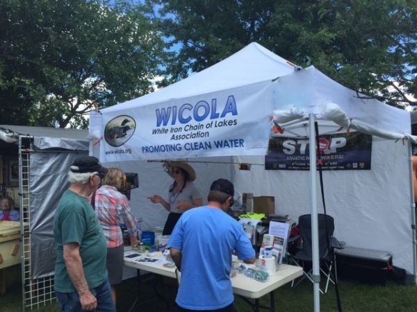
Get involved with organizations who are focused on watershed stewardship – your local lake association, like the Lake of the Woods District Stewardship Association, or Lake of the Woods Water Sustainability Foundation, a local Soil and Water Conservation District (in Minnesota), or environmental committees affiliated with your local municipality or county are just a few examples. The 2018 and 2019 Binational Lake Association Network Events were attended by members of the WICOLA Board.

This series is provided as part of the International Watershed Coordination Program of the Lake of the Woods Water Sustainability Foundation (www.lowwsf.com).

Kelli Saunders, M.Sc., is the International Watershed Coordinator with the Lake of the Woods Water Sustainability Foundation.

Sep
20

Does it Really Matter What I Do?

By Kelli Saunders

The short answer is YES.  Reducing impacts on our environment has to be a collective initiative and every single person and the changes they make will have an impact.  In past articles, I’ve focused on what agencies are doing to understand watershed issues and work towards protection.  Today and next week, I’ll focus on ideas that we, as watershed citizens, can all do.

One of the common concerns I hear is whether septic systems are having an impact on water quality. If not properly maintained, septic systems can pollute the lake with phosphates and bacteria. Grease, oils, harsh cleaners and supposedly “disposable” personal products can really stress out a septic system, clog it up and reduce its efficiency. Follow this mantra: “If in doubt, don’t pour it out”.  A septic system needs regular check ups and pump outs and needs to be large enough in size for the home it is servicing.

Reducing or completely eliminating fertilizer is an important consideration for everyone, no matter where you are located.  Whether you have shoreline property or not, fertilizer will find its way to the lake or river either as direct runoff at the shoreline or via storm drains.  The phosphorus in fertilizer feeds algae in the lake, so it’s best to minimize or avoid use or better yet, switch to phosphorus-free fertilizer.  When you are in the store, look for a “zero” in the middle of the three numbers on the fertilizer bag.

Keep used oil, household cleaners, paints, bug sprays and other hazardous waste out of the landfill and out of the lake.  Take these items to a hazardous waste collection depot to be recycled or disposed of properly and don’t allow any spilled materials to be washed down your driveway, where it can find its way to the nearest waterbody. .

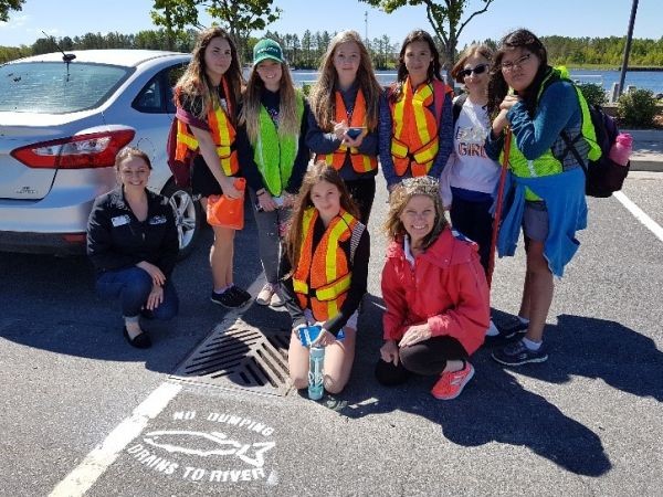
Why not grab your neighbours and all the kids and walk around the block to collect garbage?  What a great way to educate your children that throwing trash out in the environment is not a good choice and that, together, good work can get done fast.

Plant a tree!  Trees and shrubs act as natural filters and stabilizers to limit runoff and reduce soil erosion.  Soils that contain phosphorus, if eroded and washed into the lake or river, will contribute to the nutrient load.

Stay tuned for more ideas next week – pick one or two of these ideas to put into action this fall!

This series is provided as part of the International Watershed Coordination Program of the Lake of the Woods Water Sustainability Foundation (www.lowwsf.com).

Kelli Saunders, M.Sc., is the International Watershed Coordinator with the Lake of the Woods Water Sustainability Foundation. 

Sep
19

Minnesota is Losing Ice

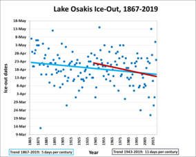
Minnesota is experiencing changes. It's getting warmer and wetter, which has shortened lake ice season. For example, Lake Osakis - an average-sized lake in central Minnesota - experiences ice-out more than a week earlier now than it did in the 1940's (see graph to the left).

Average temperatures are rising around the globe, particularly in northern regions like Minnesota. Minnesota's winters are warming faster than any other season. We don't get as cold as often anymore (see graph below).

Weather versus climate - you may wonder, what's the difference? Annual weather patterns are variable. Some winters will be cold, still more will be mild. Weather is a snapshot in time, like a photograph from childhood. Climate is measured over decades, tracking changes over the course of a lifetime.

A shortened lake ice season has environmental and cultural effects for Minnesota:

* A longer open water season, in combination with increased stormwater runoff and erosion caused by heavier rain, means that many bodies of water will experience more algae blooms.

* Warming surface waters are leading to a loss of fish habitat for many prominent species, including trout and walleye.

* Shortened and unpredictable ice cover results in condensed ice-fishing seasons.

We need more data on lakes all across the state to better understand how the ice cover season is changing.  The State of Minnesota began collecting lake ice data from citizens in the 1970's and is always looking for more volunteers. The larger the data sets available to researchers, the better we can understand the effects that changing ice cover has on lake health, local wildlife and citizen lake use. Become a MPCA Ice Reporter Today.

Sep
15

Minnesota’s Approach to Protecting Lake of the Woods

By Kelli Saunders

It’s been very interesting to watch the progress that has been made over the last 12 years or so with regards to understanding water quality conditions in this watershed.  Today, I’m going to focus on the approach used by our neighbours to the south. There is a very systematic, well funded, practical approach used by the state of Minnesota – when a water quality condition doesn’t meet the state standard, a whole process kicks into gear to study the problem and determine what is needed to fix it.

Over ten years ago, Minnesota’s water quality sampling on Lake of the Woods indicated that the lake had levels of both total phosphorus and chlorophyll-a above state standards and these contribute to algal blooms and other conditions harmful to aquatic life and recreation.  Because the state standard was not met, the U.S. portion of the lake was deemed “impaired”. Under the US Clean Water Act, states are required to develop total maximum daily load (TMDL) studies for their impaired waters – basically, this is determining the daily load of a pollutant the waterbody can handle, but stay within the standard.

The TMDL study also includes the development of a detailed implementation plan which outlines the necessary actions to restore water quality to within the standards. When a water body is restored, it can be removed from the impaired waters list. In addition, monitoring will continue over the long term to ensure standards are maintained.  The bulk of the work began in 2015 and in the summer of 2018, the final report was submitted to the USEPA and is currently under review before final approval.

The TMDL study examines the pollutant sources that are contributing to the water quality standard exceedances. These sources could include tributaries to the Rainy River, tributaries that drain directly into the lake, septic systems, wastewater treatment plants, and industrial facilities. An additional source could be the lake itself, through a process referred to as ‘internal loading’, where historically accumulated phosphorus in the lake bottom comes back into the water. Finally, atmospheric deposition can be a source when nutrients are carried into the system through wind currents and precipitation. Since Lake of the Woods has such a large surface area, the effects of atmospheric deposition will likely be higher than with most other lake TMDL studies.

Once the nutrient sources are identified, the TMDL study examines how much pollutant loading Lake of the Woods can take in without becoming impaired. Once the lake’s ‘loading capacity’ is determined, the pollution reduction needed to restore water quality is calculated by subtracting the current amount of pollution loading from the lake’s loading capacity. The TMDL study also accounts for a margin of safety and future growth.

The goal of Minnesota’s TMDL program is to address Minnesota sources of pollution that contribute to a water quality problem or impairment in Minnesota’s waters. Minnesota recognizes and cares about the downstream impacts of their nutrient sources to the waters of Canada and they have a long history of working cooperatively with Canadian partners, which predates this TMDL project. In fact, many of the numerous cooperative efforts and activities over the past 15+ years have generated significant data and information that have been directly used in the development of the TMDL. Last summer, our Minnesota partners came to Kenora to talk about the TMDL and will share more information once the study is approved and finalized.

This series is provided as part of the International Watershed Coordination Program of the Lake of the Woods Water Sustainability Foundation.

Kelli Saunders, M.Sc., is the International Watershed Coordinator with the Lake of the Woods Water Sustainability Foundation. 

Sep
05

Civic Engagement – We All Can Play a Role in Protecting Water Quality

By Kelli Saunders

Last week, I mentioned that there are three components to the International Watershed Coordination Program here in our basin, one of them being the “local” or grassroots component.  This is where you come in.  Protecting water quality is everyone’s responsibility, but how does an individual find a way to make a difference?  Let me offer a few ideas based on the civic engagement work we do with our partners.

We are so fortunate to have over 40 lake associations in this watershed – most are in Minnesota, but the largest in Ontario is right here!  The Lake of the Woods District Stewardship Association (LOWDSA) has been promoting good water stewardship for over 50 years and absolutely anyone, not just waterfront residents, can be a member.  They have a strong environmental focus and we partner with them regularly.  For the past three summers, for example, LOWDSA has been a key partner in our cross-border drain stencil project working with children in the community to paint the message “A Healthy Lake Starts Here” or “Dump No Waste” beside storm drains - to date, well over 300 drains have been painted in three communities, reminding us that only rain should go down the drain, because these drains direct runoff directly to our nearby waterbodies.  As a way to support the many lake associations in the basin, we also host an annual Lake Association Network Event, bringing together like-minded individuals who are motivating their members to be good stewards in a wide variety of ways.

This past year, as a partnership with MPCA, Koochiching Soil and Water Conservation District and University of Minnesota, we are conducting one on one interviews to discuss values around water and the barriers and opportunities to being a good lake steward.  With opinions coming in from Minnesota and Ontario, it will be interesting to compile the responses; the end goal is to be sure we are helping break down the barriers and understanding what motivates individuals to become involved. 

On both sides of the border, there is an army of volunteers who collect water clarity data and water samples that are analyzed for phosphorus.  This is civic engagement at its best, supported by the provincial and state governments.  In Ontario, volunteers with the Lake Partner Program collect total phosphorus samples and make monthly water clarity observations on their lakes during the summer months. By measuring total phosphorus and water clarity, it is possible to detect long-term changes that may be due to impacts of shoreline development, climate change and other stresses. Phosphorus is measured because it is the nutrient that stimulates algal growth in the majority of Ontario lakes.  Similarly, in Minnesota, the Citizen Lake/Stream Monitoring Program has a network of volunteers who conduct water clarity tests at least twice a month each summer at designated locations on lakes or streams. To determine water clarity, volunteers find the disappearance/reappearance point of a Secchi disk as it descends into a lake or a specially designed stream collection tube. With both programs, the data being collected by these volunteers are often the only data that exist in more remote locations and are very valuable.

These are only a few of the civic engagement projects ongoing here in the basin – there are lots of ways to get involved - if you are interested in any of these initiatives, please contact me at This email address is being protected from spambots. You need JavaScript enabled to view it..  Next week, I’ll be focusing on the work Minnesota is doing to get their portion of Lake of the Woods off the state’s impaired waters list!

This series is provided as part of the International Watershed Coordination Program of the Lake of the Woods Water Sustainability Foundation (www.lowwsf.com).

Kelli Saunders, M.Sc., is the International Watershed Coordinator with the Lake of the Woods Water Sustainability Foundation. 

Sep
01

International Coordination – Alive and Well!

By Kelli Saunders

About eight years ago, with coworkers on a boat on Rainy Lake, ideas were brewing around the need to somehow coordinate and harness the energy and dedication of individuals working on water issues in this basin and break down communication barriers.  Not long after, the concept of establishing an international watershed coordination program was born - a program that would be supported by partners, for partners.  My position as International Watershed Coordinator began, with a focus on three levels of integration that, together, make up the International Watershed Coordination Program (IWCP): international, regional and local. Over the years, the Lake of the Woods Water Sustainability Foundation has steered this ship by contributing as a funding partner and facilitator, with our longstanding partners from south of the border, the Minnesota Pollution Control Agency and Koochiching Soil and Water Conservation District.  Along the way, the province of Manitoba has contributed and, currently, our partners include the International Joint Commission (IJC) and Environment and Climate Change Canada (ECCC). 

The IWCP provides bi-national coordination and communication of research, management and citizen engagement for the shared waters of our basin.  The three spheres that the program integrates are:

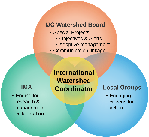
  • International – providing project management services on special projects for the IJC’s International Rainy-Lake of the Woods Watershed Board (IRLWWB), like developing an adaptive management approach to managing water levels, updating water quality objectives for the basin, building relationships with First Nation communities, Tribes and Métis;
  • Regional – facilitating a group of resource managers on issues such as aquatic invasive species, algae blooms and nutrients, research partnerships and monitoring.  This group was brought together under the 2009 International Multi Agency Arrangement (IMA);
  • Local – developing innovative grass-roots projects with local partners to help spread the word around water stewardship; examples include recruiting volunteer water samplers, working with kids to paint messages beside storm drains that nothing but rain should go down the drain (we’ve painted these in Kenora, ON, Fort Frances, ON, International Falls, MN and Rainier, MN); interviewing people about their values around water; hosting an annual binational lake association gathering and connecting individuals through our Watershed News newsletter and our recently launched website (www.rainylakeofthewoods.org).

This watershed continues to be a very busy one and there is an ongoing need to coordinate across the border, especially as we start to work towards turning science into action.  What makes this basin so unique is the willingness to work together on issues wherever possible and it has become a bit of model for cross border collaboration across the Canada/U.S. boundary from coast to coast, of which we are all very proud.

This series is provided as part of the International Watershed Coordination Program of the Lake of the Woods Water Sustainability Foundation. This story has been compiled from a number of articles from our science partners on our Foundation website blog at https://lowwsf.com/blog.

Kelli Saunders, M.Sc., is the International Watershed Coordinator with the Lake of the Woods Water Sustainability Foundation. 

Aug
26

Final Ely Living with Fire Speaker Series

Fire and Water: Emily Creighton, Hydrologist on the Superior National Forest

Location:  Ely Senior Center

                   27 First Avenue East   Ely, MN 55731

                   Snacks provided.

August 26, 2019 Monday Time 6:00 – 7:00 PM FREE

Synopsis:

Water resources make up a big part of the overall fire-dependent ecosystem of Northeast Minnesota.  So how does the presence of fire affect the lakes, streams, wetlands, and groundwater we as Minnesotans care so much about?  In this talk, I’ll describe the effects of wildfire and prescribed burning on hydrology, water quality, aquatic connectivity, aquatic wildlife and overall watershed health. We’ll discuss wildfire firefighting measures in the context of water resources, and

What you as a homeowner can do to minimize impacts to water resources from fire.

Bio: As a hydrologist, she is concerned with all facets of watershed and water resource health, and how the activities that occur on the Forest – including a whole range of human-caused or natural events, such as prescribed burning and wildfire, timber harvest, climate change, or recreational use, to name a few - might impact the those resources.  Emily holds bachelor’s degrees in Atmospheric Science and Earth Science from Northland College and a Master’s degree in hydrology from the University of New Hampshire.

Aug
25

Minnesota list of infested waters is online

You can find the updated Minnesota DNR list of infested waters online!

The Minnesota Department of Natural Resources (DNR) regularly updates the state infested waters list, which includes Minnesota lakes and rivers containing certain aquatic invasive species. The DNR will add a lake, river, pond or wetland to the infested waters list if it contains an aquatic invasive species that could spread to other waters. The DNR may also list a lake, river, pond or wetland as infested if it is connected to a body of water where an aquatic invasive species is present. You can view an interactive map of most infested waters  on the DNR EDDMapS Midwest website.

If you harvest bait, fish commercially, or divert or take water from lakes or rivers on this list, you may need to follow special regulations.

  • The most complete and up-to-date list of infested waters is an Excel spreadsheet available on the DNR website.
  • Using the Excel spreadsheet, you can sort, search or filter the list by water body name, county, species, or year. If you have questions about what the information means, see the tab called “Column descriptions”.

Questions about the infested waters list?

Contact Kelly Pennington, Aquatic Invasive Species Prevention Consultant This email address is being protected from spambots. You need JavaScript enabled to view it.

Aug
14

MPCA Citizen Monitoring Programs

WICOLA Members participate in two types of MPCA Citizen Monitoring Programs: CLMP+ (Advanced Citizen Lake Monitoring Program) and CLMP (Cooperative Lakes Monitoring Program)

The WICOLA water monitoring program (CLMP+) is conducted monthly and involves:

1. Water Sampling
Water samples are collected into bottles at a depth of 2 Meters for laboratory analysis. Test results include: Total Phosphorus, Total Kjeldahl Nitrogen, Sulfate, and Chlorophyll A.

2. Sonde Readings
A Sonde (or probe) is a specialized water quality monitoring instrument. Readings are conducted at the surface and then every meter throughout the water column down to the bottom and are recorded on a data sheet. Readings include:  Temperature, Dissolved Oxygen, Conductivity, and pH.

3. Secchi 
Secchi Disc is a circular disk 30 cm / 12” in diameter used to measure water transparency. The disc is mounted on a line and lowered slowly down in the water. The depth at which the disk is no longer visible is recorded and taken as a measure of the transparency of the water.

4. Invasive Species
Invasive species tests are conducted at a depth of 15 to 20 feet. Water is collected in a specialized container with a magnifier and viewed on the surface to look for Spiny Water Fleas.


WICOLA volunteers also participate in the Minnesota Pollution Control Agency’s Citizen Monitoring Programs (CMP) which provides the opportunity for anyone in Minnesota with an interest in lakes and streams to participate in a simple, yet meaningful citizen science monitoring program.

CMP volunteers take weekly measurements of water clarity (transparency) during the summer using equipment provided by the MPCA. These collaborative programs represent one of the best methods for obtaining large-scale, long-term water quality data in Minnesota. For many lakes and streams, CMP data are the only regularly collected water quality information available, making this work by CMP volunteers invaluable.

The Minnesota Pollution Control Agency’s Citizen Monitoring Programs Page contains links on the right hand side of the page - Uses of data collected by CLMP volunteers - that have a further explanation of how they use the data. Track lake and stream water clarity changes over time has the entire set of data through 2017 and our lakes are listed under Lake/St Louis Counties.

Aug
10

Algae 101

By Kelli Saunders, M.Sc., International Watershed Coordinator with the Lake of the Woods Water Sustainability Foundation

Algae are microscopic, plant-like organisms that can occur naturally in ponds, rivers, lakes and streams. Although they can be olive-green, red or black, depending on the species, the blue-green version most of us are familiar with are actually a group of bacteria, called cyanobacteria.  In the Rainy-Lake of the Woods watershed, algae have been around for years and, in fact, explorers, fur traders and settlers reported them 200 years ago.  Algae thrive on the nutrients (mainly phosphorus in this part of the country) in the water – some is natural and some is human-caused, like agricultural and stormwater runoff or leaching from septic systems.  In some cases, where nutrients are excessive, the algae can grow to the point where they combine and form a bloom or a surface scum.  When the ecosystem is in balance, the critters that eat algae grow in numbers as the algae grows, but with cyanobacteria, the colonies get so large that the consumers can’t keep up, and the end result is a bloom. While these blooms are unpleasant and can smell, some species of the blue-green algae naturally produce and store potentially harmful toxins that are released into the water and this is when algae really become an issue. 

Toxins in algae are found in many Canadian freshwater lakes and elevated levels of toxins have been reported on Lake of the Woods in some summer months.  Strange that we can even find blooms on smaller lakes that are only accessible by canoe and have no development, but we can.  The culprit, in part, is climate change – not only are average water temperatures higher on Lake of the Woods, but it has become generally less windy, both of which may be playing a part in the algae problem. An analysis of ice-out records shows that the northern part of Lake of the Woods is having an average 28 more days of open water each year, giving another full month to grow algae annually.  

Now that we’ve spent some time learning about algae, we will move on to other issues facing the watershed – some close to home and some not so close but still important to be aware of, given we are the downstream recipients of everything that happens upstream.

This series is provided as part of the International Watershed Coordination Program of the Lake of the Woods Water Sustainability Foundation (www.lowwsf.com).

Aug
05

2019 Blueberry Festival Recap

Volunteers from WICOLA and Partner Organizations spoke with hundreds of visitors at the 2019 Annual Blueberry Festival. Visitors to the booth welcomed the information provided about the spread and prevention of aquatic invasive species, and water monitoring in WICOL and surrounding lakes throughout the watershed.

Booth Visitors by Day

Friday                      367

Saturday                  420

Sunday                    232

Total Visitors       1,019

Part of the education on Rusty Crawfish involved identification of this invasive species. Those who visited the booth were able to sign up for a handmade Kubb Lawn Set which was won by Abby, from Angora, MN. Congratulations to Abby!

Also a special thanks to the volunteers who took time away from their normal schedules to man the WICOLA booth.

Aug
04

Starry Trek 2019: Volunteers Needed for Citizen Science Event

Location; Kawishiwi Ranger Station, at the picnic table outside the building (there will be a tent & signs set up at that site). Participants are asked to register online for the event at www.StarryTrek.org

Volunteers from across Minnesota are needed on Saturday, August 17 to participate in a statewide search for starry stonewort, one of Minnesota’s newest aquatic invasive species. Hundreds of volunteers will gather at local training sites statewide to learn how to identify starry stonewort and other aquatic invasive species and search for them in area lakes.

Starry stonewort is an invasive algae that was first found in Minnesota at Lake Koronis in 2015 and has since spread to fourteen Minnesota lakes. Early detection of this species is critical for control. Starry Trek volunteers have found starry stonewort in two lakes – Grand Lake in Stearns County and Wolf Lake at the Hubbard/Beltrami County border – as well as other aquatic invasive species like Eurasian watermilfoil and zebra mussels during this event.

The 2017 discovery of starry stonewort in Grand Lake led to the lake association and Minnesota DNR rapidly mobilizing to hand-pull the infestation. This early intervention has widely been considered a success, with starry stonewort continuing to be limited to the small area near the public access where it was initially discovered.

“This event is a terrific way for people to get outdoors, get educated about aquatic invasive species, and help protect their area lakes,” said Megan Weber, Extension Educator with the Minnesota Aquatic Invasive Species Research Center. “The information we gain at this event helps researchers and managers understand its current distribution and potentially take action if new infestations are found.”

No experience or equipment is necessary to participate in Starry Trek. Expert training on monitoring protocols and starry stonewort identification will be provided on-site. This event is free, but registration is requested. Children under 18 must be accompanied by a parent or legal guardian.

“We’re delighted to be partnering with the Minnesota Aquatic Invasive Species Research Center for this event,” said Sonja Smerud, AIS Coordinator, Lake County SWCD. “Protecting our lakes for future generations is really important to us all, and we want to do make sure we’re doing the best we can to prevent the introduction and spread of AIS.”

There are currently 27 local training sites committed around the state, including one in Fall Lake Township, Lake County, Minnesota.

Again, our local rendezvous site will be at the Kawishiwi Ranger Station, at the picnic table outside the building (there will be a tent & signs set up at that site). Participants are asked to register online for the event at www.StarryTrek.org 

Volunteers will meet at their local site for training, then will be sent to nearby public water accesses to check for starry stonewort. At the end of the day, they’ll return to the local training site to report their findings. For a full list of the sites and other FAQs, please visit www.StarryTrek.org.

The Minnesota Aquatic Invasive Species Research Center works across the state to develop research-based solutions that can reduce the impacts of aquatic invasive. A portion of the funding for this program is provided by the Environment and Natural Resources Trust Fund. Learn more at www.maisrc.umn.edu.

For statewide information, contact:

Megan Weber, Extension Educator

Minnesota Aquatic Invasive Species Research Center

This email address is being protected from spambots. You need JavaScript enabled to view it.

763-767-3874


For local information, contact:

Sonja Smerud

Lake County Soil and Water Conservation District (SWCD)

This email address is being protected from spambots. You need JavaScript enabled to view it.

(218) 834-8513

Jul
20

Minnesota DNR calls for loon watch after suspicious deaths

West Nile virus has been confirmed in two dead loons; suspected in others.

By Tony Kennedy Star Tribune JULY 18, 2019

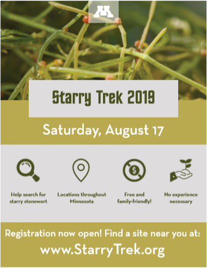
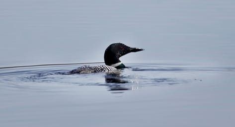
Arrowhead Lake in Britt, Minn., is home to the Laurentian Environmental Center, where plenty of nature lovers watch the comings and goings of the lake’s nesting pair of loons.

When one of the adult birds died last month, citizen-scientist Sherry Abts of Ely heeded a call to investigate. She paddled out in a kayak to find the remaining adult loon acting strangely. It died within days, despite no visible signs of injury.

Those deaths and six to eight other reports of loons dying this year in St. Louis County have state wildlife officials slightly on guard. Starting this week, the Department of Natural Resources is encouraging lake observers to report unusual loon mortality.

West Nile virus — which isn’t new or preventable — is to blame for at least three of the deaths so far, an expert at the University of Minnesota said Wednesday.

“There seem to be more calls than we normally get of loons dying off,” said Gaea Crozier, a nongame wildlife specialist for the DNR in Grand Rapids. “It’s enough that we’re starting to wonder if there is something going on that we should be concerned about.”

Crozier said the slight uptick in reported loon deaths in May and June has somewhat subsided. But lake residents and other loon watchers are being asked to contact the agency if they see several birds dying on a single lake. West Nile virus in loons can’t be treated, but knowing the cause of death can help rule out other, preventable causes of death, she said.

In addition to hearing about the two loon deaths on Arrowhead Lake, Crozier has received reports of loons dying on lakes around Biwabik, Eveleth, Ely and Hibbing.

Abts and friends from a group known as Ely Field Naturalists collected four of the dead loons on their own and had them delivered for testing last month to the University of Minnesota’s Veterinary Diagnostics Lab in St. Paul. One of the birds, recovered from a nest on Snowbank Lake near Ely, was skeletal, and couldn’t be tested.

Dr. Arno Wuenschmann at the University of Minnesota said the state Department of Health has concurred with his finding that the other three birds died from rapid disease that developed from West Nile, a virus carried by mosquitoes. One of the tested birds was found on Bass Lake in Biwabik.

“I’m not completely shocked,” Wuenschmann said.

Confirmation of the disease in loons is rare, partly because the birds have dense bones that cause them to sink when they die on a lake. Other carcasses are quickly picked apart by scavengers. But 14 years ago, Wuenschmann confirmed that an entire family of four loons had died after being infected by West Nile virus on Sandy Lake near Zimmerman.

He said the virus seems to kill loons quickly, just as it attacks crows, northern owls and other birds.

Crozier said another threat to loons in Minnesota is discarded fishing tackle. Pieces made of poisonous lead are sometimes eaten by the birds. But in the big picture, the DNR said, Minnesota’s loon population has been holding steady at about 12,000 birds.

Still, the DNR is now asking lake watchers who observe two or more dead loons on a single lake with no obvious injury or cause of death to contact the agency for tracking and possible testing. Specimens can’t be tested unless they are preserved and in good condition.

Jul
19

What is a Watershed and what’s unique about ours?

By Kelli Saunders, published July 10th, 2019  (minor editing for style)

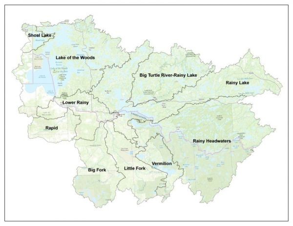
Everyone lives in a watershed and we live in what’s called the Rainy-Lake of the Woods Watershed, a massive basin, with its beginnings (called headwaters) only a short distance west of Lake Superior. A watershed is like a bathtub or catch basin, defined by high points and ridgelines that descend into lower elevations and stream valleys. A watershed carries water that is “shed” from the land after rain falls and snow melts. Drop by drop, water is channeled into the soils, groundwater, creeks and streams, making its way to larger rivers, lakes and eventually, the sea. Water interacts with all that it comes in contact with – the land it traverses and the soils through which it travels. Most importantly, what we do to the land and air affects water quality for all communities living downstream from us.

The Rainy-Lake of the Woods Watershed is 69,750 sq. km, roughly 400 km east to west and 260 km north to south. About 41% of the watershed is in the U.S. and 59% is in Canada. If you’ve travelled to Atikokan or Upsala in Ontario or Ely or Cook in Minnesota, you were still in our watershed. If you’ve paddled the Turtle River in Ontario or fished in Vermilion Lake in Minnesota, you were still in our watershed. Approximately 14% of the watershed is open water; where there is land, 93% is covered by forest or grassland, and much of that is within provincial parks and national forests. Only 6.4% of the land base is agricultural, mostly found in the lower Rainy River area.

In our watershed, all the water flows towards either the Rainy River or Lake of the Woods, funnels into the Winnipeg River at Kenora and eventually reaches Lake Winnipeg. About 70% of the water that flows into Lake of the Woods comes directly from the Rainy River, which, of course, is half in Canada and half in the U.S. This truly makes our watershed unique – water knows no boundaries. As demonstrated naturally here, although the water comes from two countries, it meets up in one common place – right here in Kenora where our outlets steer it off to travel into another province to yet again mingle with new water.

Kelli Saunders, M.Sc., is the International Watershed Coordinator with the Lake of the Woods Water Sustainability Foundation.

Jul
13

Boating Guidelines; Rules & Safety

Enjoying Minnesota’s lakes and rivers by boat or canoe is a wonderful privilege. That privilege comes with serious responsibilities. Fun boating is safe boating, so please follow the Minnesota DNR Boating Guidelines and contact the Department of Natural Resources (DNR) with any questions you may have.

NAVIGATION RULES

Passing

  • When overtaking another watercraft going in the same direction, the craft being overtaken must maintain course and speed.
  • The passing watercraft must keep a sufficient distance to avoid collision or endangering the other craft from its wake.

Meeting

  • When two watercraft approach each other “head-on,” each must alter course to the right to avoid collision.
  • If the two watercraft are far enough to the left of each other, no change in direction is needed for safe passage. Both watercraft will maintain their course and speed to pass clear of each other.
  • Keep to the right in narrow channels.

Crossing

  • If two watercraft approach each other at a right angle, the watercraft to the right shall have the right-of-way.

Nonmotorized Craft

  • Nonmotorized craft (sailboats, canoes, etc.) have the right-of-way over motorized craft in all situations, except when the nonmotorized craft is overtaking or passing.
Jul
08

WICOLA at the Blueberry Festival; July 26-28th

Come Visit Us at the Blueberry Arts Festival.

Come by the WICOLA Booth (#172) to visit, check out the AIS (Aquatic Invasive Species) materials, learn how to protect our lakes, and enter the “guess the number of Rusty Crayfish” contest to win a special prize. WICOLA members and representatives from partner organizations will be at the booth to answer questions, to provide updates on AIS in Northern MN and to share AIS prevention information.

Come Volunteer at the Blueberry Arts Festival.

Thinking about becoming more involved in WICOLA and our Chain of Lakes?

You can have a fun and meet a lot of people in just a couple of hours. Consider volunteering at the WICOLA Booth where you will be teamed with experienced members and representatives from partner organizations. You select the days and times you would like. If interested, contact Mary Setterholm; 612-741-8761 or This email address is being protected from spambots. You need JavaScript enabled to view it.

Jul
03

Short Term (Vacation Home) Rental – St. Louis County

St. Louis County Planning and Community Development Department will be hosting informational open house meetings to discuss proposed Short Term (Vacation Home) Rental permitting standards. Public input received during development of the St. Louis County Comprehensive Land Use Plan was strongly in support of looking at ways to improve the regulation of short term rentals. St. Louis County has important roles impacting the short term rental market in land use administration, property classification and assessment, and on-site sewage treatment compliance. Please join them to discuss and provide feedback on the proposed short term rental permitting process.

Locations and Dates

  • Tuesday, July 9, 2019  
    Open House 4-7 pm
    St. Louis County Public Works Building
    Lower Level Training Room
    7823 Highway 135 
    Virginia, MN 55792
  • Wednesday, July 10, 2019  
    Open House 4-7 pm
    Rice Lake City Hall   
    4107 W Beyer Road 
    Duluth, MN 55803

If you have any questions about the Short Term (Vacation Home) Rentals for the upcoming open house meeting, please contact: Jenny Bourbonais, Planning Manager, Land Use Division (218) 749-0629, This email address is being protected from spambots. You need JavaScript enabled to view it.

Click on the links for more information from St. Louis County; Vacation Home Rentals and Comprehensive Land Use Plan

Also please see the WICOLA Spring Newsletter (Page 3) on this subject; 2019 WICOLA Spring Newsletter